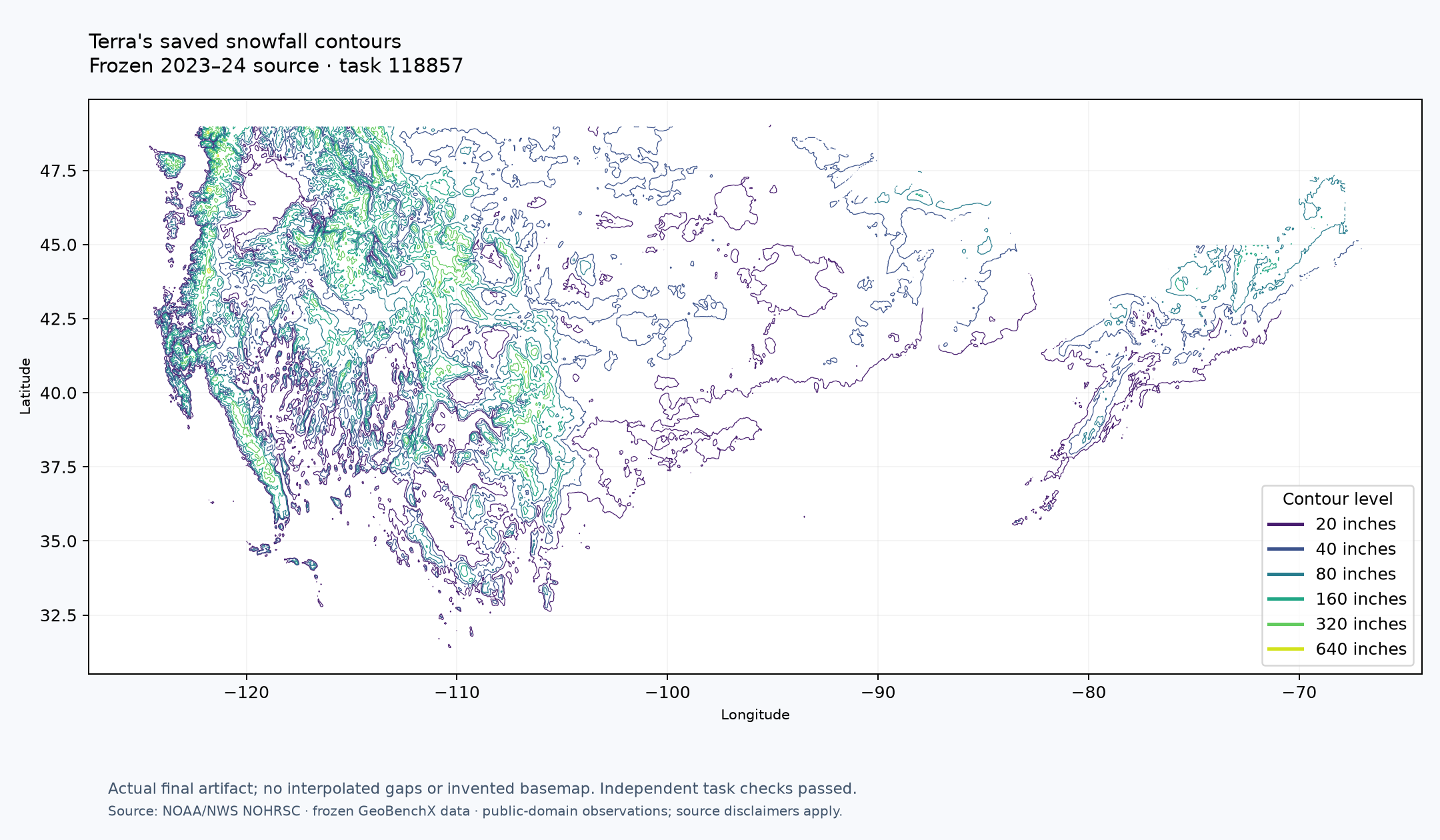
Chart contour lines for accumulated snow fall in winter 2023-2024 in USA
The question
118857Chart contour lines for accumulated snow fall in winter 2023-2024 in USA
Exact submitted task and declared adaptations
Chart contour lines for accumulated snow fall in winter 2023-2024 in USA

Task conventions: Use band 1 of the frozen snow_previous raster at the original grid without resampling, smoothing or clipping. Draw the explicit contour levels [20, 40, 80, 160, 320, 640] in inches. These levels are a disclosed evaluation convention, not a requested interval. Use piecewise-linear marching-squares isolines through pixel-center values, low-valued connectivity at ambiguous saddles. Respect the native mask, NoData and nonfinite cells; do not bridge holes or extrapolate at the outside edge. Apply any source scale and offset. NoData means unknown, never zero. Preserve source coverage; levels outside the observed range may have no line. Do not substitute a current raster. Count nonempty requested contour LEVELS, not polyline fragments. The population-count raster, where supplied, is people per original cell; do not label it population density.


Deliver an inspectable vector contour artifact and add it to the map with a level/units legend. End with one fenced JSON object containing: count (number of nonempty requested levels), unknown_count (number of masked or nonfinite source pixels), coverage_note, selection: {collectionId,itemId,assetKey}, level_field, feature_count (actual contour feature rows), map_layer_id. Explain the source season/year, units, missing coverage, and visual relationship where an overlay is requested.

Delivery format: provide the answer object with all fields specified above as final_response on assess_result, alongside the inspected final artifact_refs. This replaces the JSON-code-block formatting requirement above. Blue attaches your explicit selection to the accepted final answer. Finish with a concise ordinary-language answer agreeing with that selected result; do not duplicate the JSON in chat.

Supplied immutable inputs:
[
  {
    "name": "US snowfall, 2023\u201324 frozen season",
    "edition": "2023-09-30 to 2024-09-30",
    "units": {
      "band1": "inches"
    },
    "collectionId": "blue-generated--[resource id withheld]",
    "itemId": "[resource id withheld]",
    "assetKey": "data"
  }
]
Outcome & verification
Independent artifact and delivery checks passed.
- Duration
- 10m 25s
- Recorded Blue tool calls
- 42
- Total tokens
- 1,160,583
- Model cost
- Not recorded
- Application revision
- d50497ea9084f29c91b05406688f87035df98d8a
- Release
- terra-geobenchx-v1
Recorded final answer
Independent checks
These checks are separate from the agent's own assessment. A successful job or an assertion of success is not enough to pass.
- Expected count
- 6
- Reported count
- 6
- Computation verified
- Yes
- Answer fulfilled
- Yes
Full grading and rubric record
{
  "expectedCount": 6,
  "actualCount": 6,
  "expectedMetrics": null,
  "actualMetrics": null,
  "computationCorrect": true,
  "answerFulfilled": true,
  "adjudication": null,
  "qualification": null,
  "reasons": []
}
Recorded investigation findings
The agent's reported hypotheses and assessments, retained as evidence of its process—not independent proof that the answer is correct. Failed calls retain their requested verdict, not an accepted assessment.
run_trial · completed
Does the supplied 2023–24 snowfall raster produce mask-aware contour lines at the requested inch levels on band 1, and what are the complete-source missing-cell count and observed range needed to report nonempty levels?
assess_trial · completed · assessment: sufficient
The full-extent trial used the exact supplied raster selection, band 1, and explicit levels 20, 40, 80, 160, 320 and 640 inches. Full-raster statistics reported minimum 0.0, maximum 870.6484985351562, missing_count 1032448, valid_count 511052, scale 1.0 and offset 0.0. The contour output is a vector line dataset with fields contour_id and level, units level=inches, 2657 feature rows, and six distinct nonempty requested levels. The spatial preview shows lines broken by gaps and edge terminations rather than bridged holes or extrapolated outside coverage, which is consistent with the requested mask-aware contour method.
assess_result · completed · assessment: sufficient
The published band 1 statistics table for the supplied 2023–24 snowfall raster is sufficient. It confirms full-source minimum 0.0 inches, maximum 870.6484985351562 inches, valid_count 511052, missing_count 1032448, nonfinite_count 0, scale 1.0 and offset 0.0.
assess_result · completed · assessment: sufficient
The published contour result is sufficient. It is an inspectable vector line artifact derived from the supplied 2023–24 frozen-season snowfall raster using band 1 and the requested inch levels. The final artifact has 2657 contour features, a level field in inches, six nonempty requested levels, and a verified live map layer.
Output previews
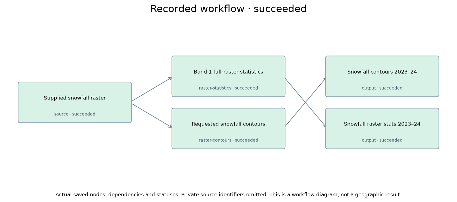
Recorded workflow
- 01
Requested snowfall contours
Recorded raster-contours · succeeded
- 02
Snowfall contours 2023–24
Recorded output · succeeded
- 03
Snowfall raster stats 2023–24
Recorded output · succeeded
- 04
Supplied snowfall raster
Recorded source · succeeded
- 05
Band 1 full-raster statistics
Recorded raster-statistics · succeeded
- 06
Requested snowfall contours
Recorded raster-contours · succeeded
- 07
Supplied snowfall raster
Recorded source · succeeded
- 08
Band 1 full-raster statistics
Recorded raster-statistics · succeeded
- 09
Band 1 full-raster statistics
Recorded output · succeeded
- 10
Requested snowfall contours
Recorded output · succeeded
Activity
Recorded actionsRecorded observable actions only, not private reasoning. Raw payloads, geometry, private links and credentials are omitted; full evidence is retained privately. Activity/workflow lists bounded at 500 entries.
Progress update
I’ll check the saved analysis context, inspect the supplied snowfall raster, and test a minimal contour workflow before I save the production method.
Progress update
I found the core Blue analysis tools. Next I’m checking the raster metadata and the exact contour/vector-display processor so I can keep the lines on the source grid and publish the result as a real map layer.
get_analysis
Recorded tool call · completed
get_collection
Recorded tool call · completed
get_map_context
Recorded tool call · completed
list_processors
Recorded tool call · completed
list_processors
Recorded tool call · completed
get_tool_help
Recorded tool call · completed
get_item
Recorded tool call · completed
inspect_artifact
Recorded tool call · failed
get_tool_help
Recorded tool call · completed
describe_processors
Recorded tool call · completed
inspect_artifact
Recorded tool call · failed
get_tool_help
Recorded tool call · completed
Progress update
I’ve confirmed the exact source item and the contour processor matches your convention: explicit levels, linear interpolation between pixel centers, low-valued saddle connectivity, mask-aware, no extrapolation. Now I’m recording the goal and testing the same method on the supplied raster before I save the production run.
update_analysis_brief
Recorded tool call · completed
describe_processors
Recorded tool call · completed
validate_processor
Recorded tool call · completed
validate_processor
Recorded tool call · completed
get_tool_help
Recorded tool call · completed
get_tool_help
Recorded tool call · completed
get_tool_help
Recorded tool call · completed
get_tool_help
Recorded tool call · completed
Progress update
I’ve got the exact processor schema. I’m running one private full-extent test with the supplied raster, the requested levels, and a full-raster stats check so I can confirm the output fields, missing-cell count, and which contour levels are actually nonempty before I save the final run.
run_trial
Recorded tool call · completed
Progress update
The private test succeeded. It shows band 1 ranges from 0.0 to 870.65 inches, the source has 1,032,448 unknown cells, and all six requested contour levels appear in the trial output. I’m checking the preview image and then I’ll save the production workflow from this tested method, run it, and publish the verified contour layer to the map.
get_tool_help
Recorded tool call · completed
get_tool_help
Recorded tool call · completed
get_trial_report
Recorded tool call · completed
get_tool_help
Recorded tool call · completed
get_tool_help
Recorded tool call · completed
assess_trial
Recorded tool call · completed
get_tool_help
Recorded tool call · completed
get_tool_help
Recorded tool call · completed
get_tool_help
Recorded tool call · completed
Progress update
I finished the method check and I’m saving the full production workflow from that exact tested computation now. After that I’ll run it, inspect the published artifacts, and bind the final contour layer to the map.
propose_workflow
Recorded tool call · completed
execute_workflow
Recorded tool call · completed
Progress update
The background run finished while the turn was interrupted. I’m inspecting those final published outputs now, then I’ll add the verified contour layer to the map and record the final answer object from the actual result.
get_workflow_run
Recorded tool call · completed
list_map_layers
Recorded tool call · completed
inspect_workflow_results
Recorded tool call · completed
Progress update
The run has already published the contour layer to the map. I’m doing the last verification now: inspect the final contour vector and stats table, confirm the level field and counts, and check the current map layer entry so the recorded result points to the actual displayed layer.
Progress update
I’m on the last check now: the published contour item, the published stats table, and the live map layer entry. That will let me record the exact contour selection, level field, feature count, unknown-cell count, and displayed layer ID from the final run.
list_map_layers
Recorded tool call · completed
inspect_artifact
Recorded tool call · completed
inspect_artifact
Recorded tool call · completed
Progress update
The map layer entry is confirmed. I’m pulling the finished inspection receipts for the final contour layer and stats table now so I can record the exact counts from the published outputs rather than the earlier private trial.
inspect_artifact
Recorded tool call · completed
inspect_artifact
Recorded tool call · completed
Progress update
I’ve verified the published contour vector, the published stats table, and the live map layer ID. I’m recording the final result now with the exact selected contour artifact and the inspected source-missing count from the final run.
assess_result
Recorded tool call · completed
assess_result
Recorded tool call · completed